
Tell
Members
-
Joined
-
Last visited
Everything posted by Tell
-
It's probably an unusual one for the team or they are not shifting from their belief that it's a village. Might be beyond their scope of what they can edit on their screens. I'd email them next if you feel strongly. Getting all mine throu but then I've never asked for such an edit. Just the normal stuff of missing roads, roundabouts, incorrect street names etc. Just speed limits they are tardy about changing I find. I'd ask you you but then I might get a negative score so I won't which would effect my future edit requests .
-
I get road changes in and extra roads. Doing quite well at that at the minute. There were a few month a year or so ago when they were not doing any updates from users now they are. I don't know whether they have a user group or an email option. We know what the issue is, now just a question of communicating it to them.
-
I would keep at it quoting the population size of those places (wiki links) and query whether they are using a village label rather than a town / city label. That's what's happening. I'm getting mine thru but I've never picked them up on the size of labels. I think they are Indian staff that do the validation. You probably got one who doesn't know how to change the attribute... wasn't on the screen they use, never has done it. If so they need to refer up. Although I can't believe they can't do that themselves. Just don't know how.
-
It's whether you are a user of maps or a crowd sourcer. You don't need to crowd source to use the maps but if you want to add back something to society you get a login in and contribute. Google also allows you to report inaccuracy as well. There maps are also crowd sourced. The cars going round happens from time to time with all providers. Once set up they will send a car down where there have been major changes they know about to check the precise road layout. It divides into people that moan about digital cartography and say X is better than Y and those that get a login and do something to improve the maps for the common good. That estate that John found had been put on by a crowd sourcer in their spare time for sure. Have a good guess who that was, a retired lorry driver. Suspect you won't find it on Google Maps. There was one estate round here that had been left off Google Maps for ten years (ditto Waze). I put it on Here Maps and TomTom but didn't tell Google for two years as a test of their abilities. In the end I told them with a sharp note to make up for the roundabouts I tell them about but they reject since their validation team is rubbish. By that time an aerial image that showed the estate had appeared previous cloud cover. Mapping companies are dependent on crowd sourcing once they have the maps set up. They do digitally cross check with each other. Run trace checks to see why they have phone tracks and GPS tracks in places they don't expect. Google being a marketing company is good on commercial POIs, lousy on non commercial activities as far as POIs. They don't invest in uptodate aeriel images which is why they lack road details. They can't validate user input since they can't check with aeriel images they don't have which are up to date and as far as the UK is concerned don't know about OS commercial planning maps. Certain amount of validation is run out of Indian operations... logically too remote. Needs boots on the ground.
-
Actually Tomtom did believe me when I came to enter it again today - must have passed their validation with the developers website and plan. Just not as yet passed into their production run. Nah so I keep TomTom and Here Maps up to date but let Google rot .... just to see how long it takes for them to catch up.
-
I would have put those in myself (but didn't btw) but you do run the risk of those bollards. If the aerial image tallies with the developers plans then I reckon it fine to digitise them in. You often get the house numbering on these part developed estates on the OS planning map where the houses are finished and the building block in shown. Then a chunk left grey which you might find on the developers plan and the aerial image of the buildings / concrete down, so digitise that in, then review again for house numbering latter. My pet brown field sites of old steel works . Dark winter month tasks or lock down . Find an executive development today on foot for house numbering and street name. TomTom don't believe me since its not on the OS planning map yet, probably also have old aeriel images. Here Maps do. In the postcode directory already. That's the other validation tool, house numbering and house names. Google / TomTom get street names wrong. Working round the house numbering on the OS maps and postcode directory also points to when the digital naming is incorrect. Oh what fun digital mapping is. Side hobby from a work interest many years ago when I set up digital mapping for planning purposes.
-
The later is not suppose to happen. You could see whether you can navigate onto them. They have the outline sketched of planned routes being built but they are suppose to be excluded. It can be where crowd sourcing people get a bit bloody minded and they slip through validation. Shouldn't be included till open. Tend to think new housing development where they have a barrier up is fine if it's the eventual road and not a thru road - development plan needs to be looked at - if not again people digitise the developers roads on housing estates but not the final road (you see that on Google but most of the where aerial images are incorrectly interpreted). There are a few nut case crow sourcing people that digitise mud tracks as surfaced roads then if they join to an actual road and they get thru validation that's how you end up on mud tracks in rural areas. (Report those to get them out with photographic evidence ideally). OS small area planning maps often via council web sites give the final road layout but may not tell you how it's surfaced, one way systems (obviously and speed). Bollards are shown thou for pedestrian only roads (word "posts")... again a mistake armchair mappers make in linking up roads across estates. Google had its car up a mud farm track locally which is why I see Google drivers bouncing down it . Then the armchair mappers come in see it on Google and incorrectly digitised it as a surfaced road. You notice the armchair mappers run out of steam where there is tree cover or the images aren't good. Roll for weeding out rubbish as well as putting in correct stuff via Mapcreator.
-
Any consolation Seat are the same. Fob people off telling them to use a phone app. In the UK you aren't even suppose to be able to update the maps since Mapcare isn't supported. VW and Skoda burried Mapcare some years ago making map updates free. Seat charge abroad via using Mapcare to block updates. Mapcare isn't supported in the UK so either a dealer one off fee for one map (£200s) or if it's the standard system you can use a user discovered "workaround" where you retain one file on the SD card on the new download. If a mib2 high (Columbus unit type) find a retrofitter to alter the navigation FEC. It's a cross we have to bear. Makes you feel like buying a Skoda... Karoq and Ateca come off the same production line but Seat still cobbles it's navigation with Mapcare. On the continent £600 for them to get an extention of Mapcare after the first 3 years that cost then £120. Retrofitter cheaper. Joke. Not sure how the mib3 offer works.
-
I see the German Skoda Community is going off on it now on this subject... and 7zip obviously. Stick to the VW notes on the PDF and you dont have issues. 32gb SD card, class 10, Fat 32, use 7zip to unpack to HD and then copy. If Mac, CleanMydrive app after its copied to the SD to remove Mac garbage (also delete garbage after the clean) & use Keka for unzipping on a Mac. Deviate at your peril . You got to love it.
-
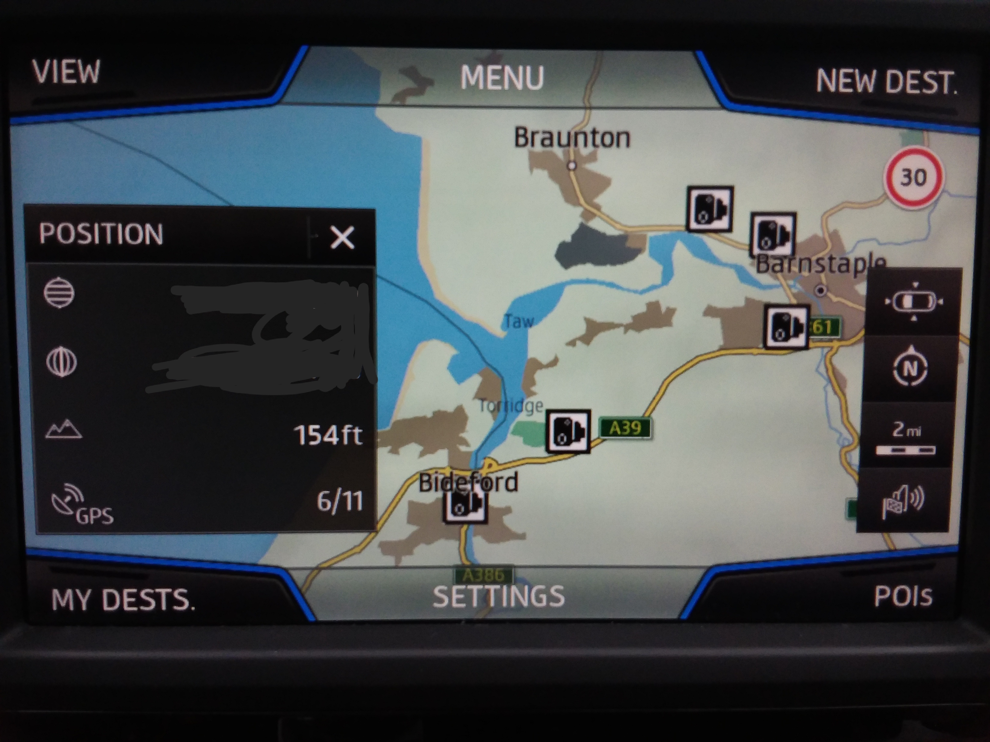
You can check the progress of TomTom reported Mapshare amendments via the Sygic app https://www.sygic.com/gps-navigation Which uses TomTom Maps, that's updated much more frequently so as well as seeing the TomTom validation team accept a report, which may not appear on their display immediately you can keep an eye on the progress of your changes in the Sygic app which will overtime appear in the Vag download. On your issue I think they just wrongly classified those places as villages rather than towns. A lower attribute than others. Telling them the population size might help as well (wiki link say). You have to evidence in reports. Openstreet has attributes to places you add, TomTom will be the same. They just got it wrong. TomTom are more tardy with reported road speed changes since anyone could ask for a speed change. I haven't had any of my requested speed changes accepted just put on pending. Here Maps collect local government road speed planning orders via a clerical task. Not sure how TomTom do it. Traffic sign recognition is your best bet in the car if worried about speeding ;)... works a dream.
-
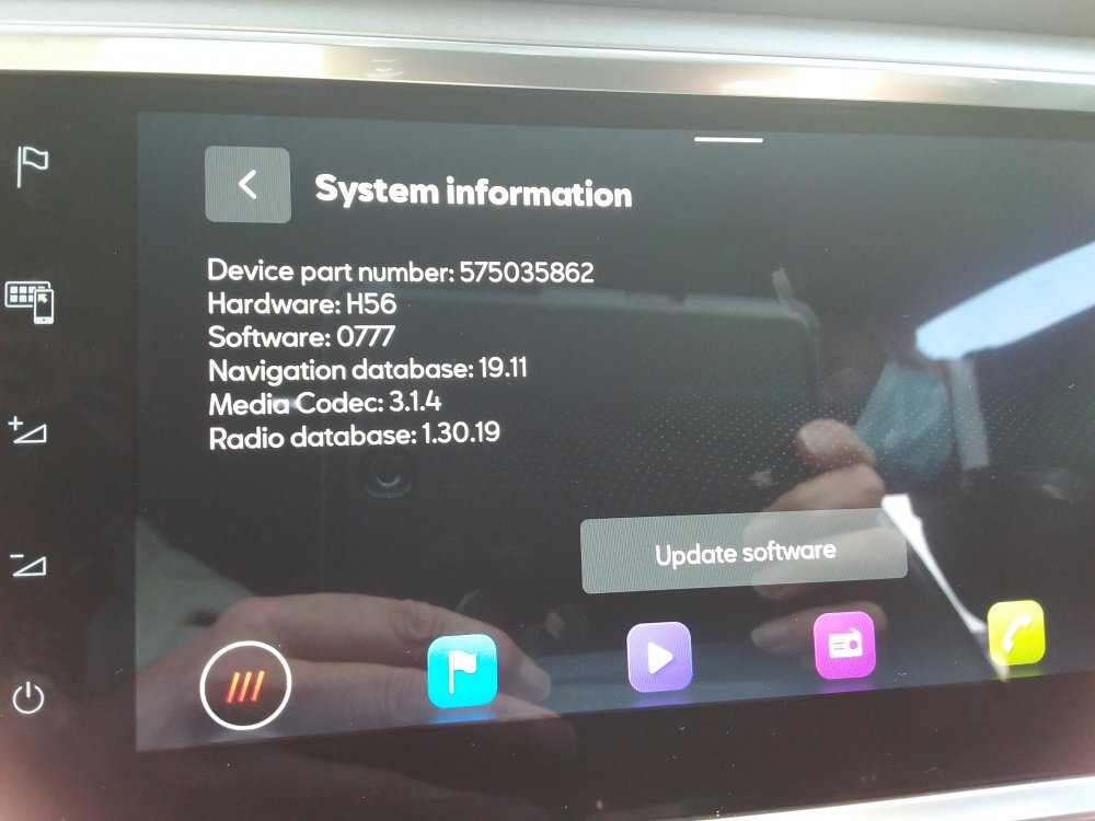
First two yes. The last one most probably is. That's the other conversation with MartiniB where I'm trying to get people with the new hardware to live dangerously and try to update it with the downloads. Question of finding the update button on those and trying to import one of the 2020 files. On the VW site under Passat 2019 model and 2020 the current one is published whilst MartiniB put the very latest links up. Yes this Skoda range: https://www.skoda-auto.com/news/news-detail/new-infotainment They have arrived to Seat on the new Leon and the face lifted Ateca and Cupra Ateca. Dubbed Mib3. What we don't know with those yet is whether the files are interchangeable between brands as mib1 and 2 are within respective model range. For Seat whether you can do it... Needs people with the unit. Early days on that.
-
From the VW manual >> Navigation map update requirements • You will need an SD card with a minimum of 32 GB of storage to update your navigation data. Volkswagen recommends the use of a Class 10 SDHC card, which is readily available to buy. • You will need the “7-Zip” data compression system with Windows operating systems. You can download this program from the manufacturer’s website. You will need an unzipping program that supports the “7z” file format should you be using another operating system. • The map material requires more than 25 GB of storage capacity. This space needs to be available on your computer’s hard drive. Your computer’s hard drive needs to be formatted as an NTFS drive to enable your computer to handle files of this size. This is standard with newer computers; with older computers please check this in File Explorer by right-clicking on the relevant drive under the “Properties” menu option. Checking the version Use the “MENU” button to check what version of map material you are using in your Discover Pro. On << The NTFS is on the drive not the SD card :). It won't grow beyond 32gb since the SSD is split that way with the spare capacity going to the jukebox, that will be the firmware can only change that. Thus they don't envisage the user using anything than an SD card of 32gb in Fat, which they come in. Ntfs is just talked about for the drive. .
-
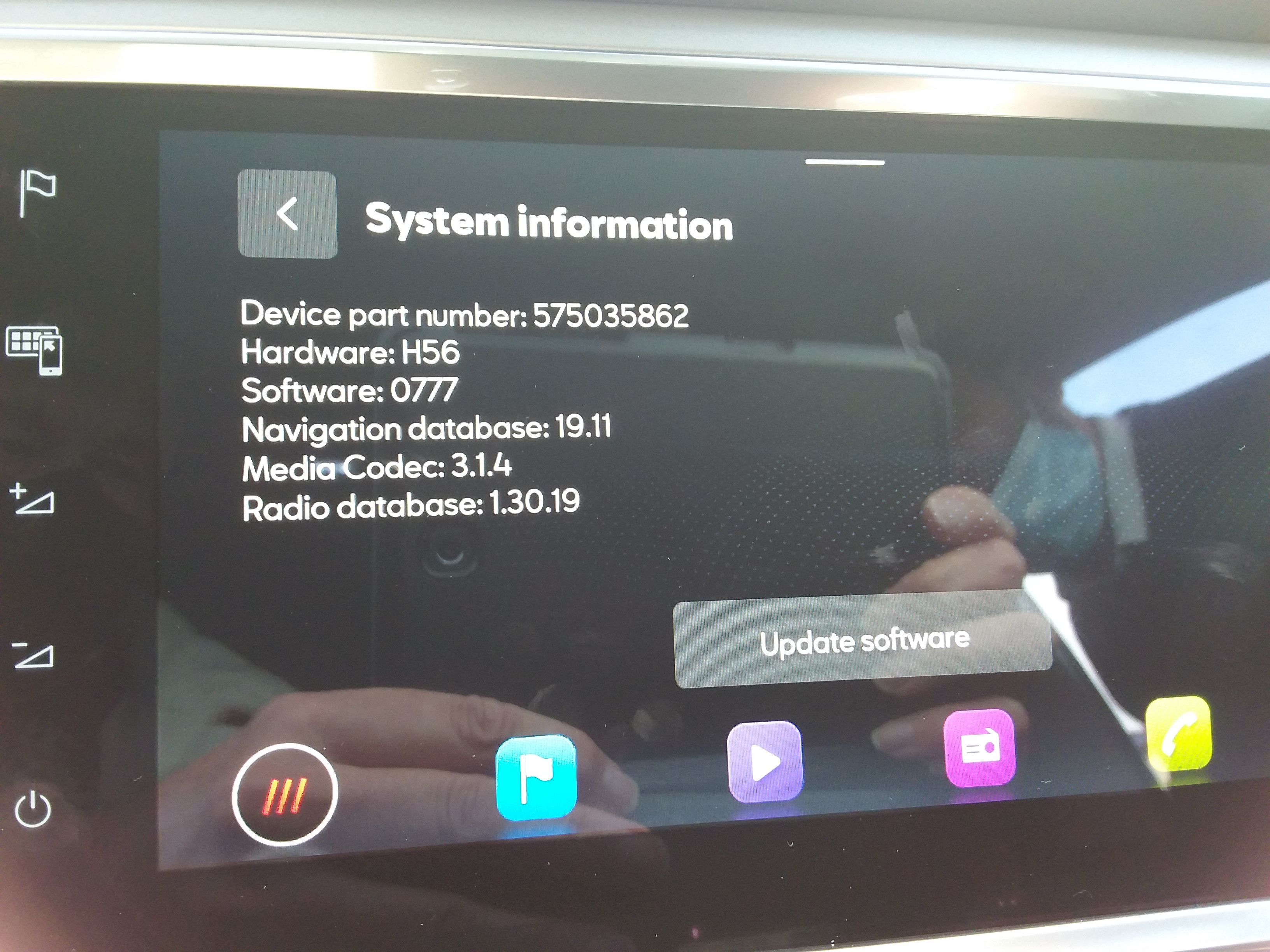
Definitely Mib2 standard (Amudsen) is TomTom cartography. I put the standard ones to them, the high ones to Here Maps. VAG changed to TomTom circa 2015 on, think it was tied to the launch. Whilst mib1 is Here Maps. So then everything is on Here Maps for mib3, the latest system. Boards put mib2 Amudsen down to Here Maps incorrectly due to history. Got one of each. mib2 standard on the partners car, mib2 high on mine... so put in update on both systems. Will take about a year to come thru threw but it will if accepted.
-
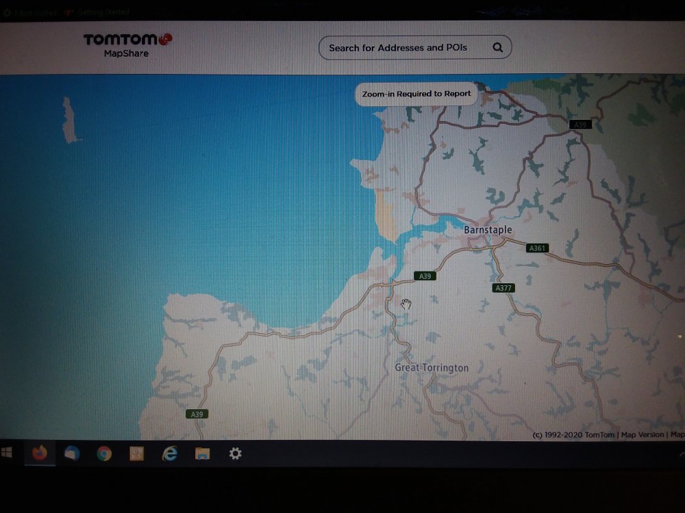
I think we are getting there... you said Map Creator that's the Mib2 High Cartography (threw me into thinking we were talking mib2 high), Amudsen mib2 is TomTom cartography TomTom Mapshare not Map Creator. It's TomTom MapsShare site you want to put it in as as bug. Picture attached. You have to register. https://www.tomtom.com/uam/UI/Login?realm=/uam&spEntityID=mapsharereporter&service=onetomtom&authLevel=0&goto=%2Fuam%2Fidpssoinit%3FmetaAlias%3D%2Fuam%2Fidp%26spEntityID%3Dmapsharereporter%26redirected%3Dtrue I suggest you put it in as an Other, Other error at that position with text and attach photo that the town name is incorrectly set up. They will ney or yay it if you keep checking. The photo should do the trick for them to check what they have set against the name (wrong property, like a village and not a town). I'd keep at them if they don't accept it.
-
It's this one which is the Seat unit in question zn1 part number as build across all new Leons, Ateca's and Cupra Atecas in the UK. News story on VW https://www.caradvice.com.au/774202/volkswagen-passat-mib3-detailed/ If you look at the VW Passat download as current for 2019 models it's the same file across the two units which explains this text "Ahead of its arrival, the company’s global division has detailed the new infotainment system. Dubbed ‘MIB3’, Volkswagen’s third-generation modular infotainment interface comes as standard with both the 8.0-inch ‘Discover Media’ and 9.2-inch ‘Discover Pro’ navigation units." So that was the 2019 model dummy run that VW had for mib3, then rolled out across VAG brands this Autumn 2020. So they have consolidated the Media unit and the Pro into the same download... the word Premium is used for one of them now. That's also true for Seat where the base unit is on Here Maps and everything is now called a Plus. It's the 5ghz Android Auto WiFi link without coord that's on the zn2 units not sold in the UK.
-
-
Those are they.... Well specifically the VW Passat from 2019 "mib3" what we don't know is whether they can be uploaded into Skoda & Seats. I don't know. Seats just have a software update button whether that does it... haven't had anybody try it. All face lifted 2020 models basically. The Passat seemed to be their test bed then rolled out across VAG in the face lifted models and new for this Autumn. Dubbed Mib3. Connect services on the map updates. Seat manual has a section on map upload, but button is missing off UK ones but has the software update. That might be like the SWDL command and work ?. Needs people to try.
-
-
Size looks identical on Co-pilot which uses Here Maps cartography e.g. looks fine. Probably a blob size parameter on the mib2 high implementation of the name. . Still would be interesting to see how its handled in mib3. Covid times and all that. Whether it's a rewrite of their display processes from the same cartography or looks identical with the "bug". Will have a look next time I sit in one at a dealer with mib3. I'm sure later today I'll find the same issue with Barnstaple v Bideford on my Seat mib2 high... let you know if it's perfect .
-
You can do but the issue is when people start formatting the SD standard map card (not the high) in anything other than Fat32, doesn't work. Or a 32 gb SD card to upload to the high. Reports of running out of space due to the indexing. Skoda German Community Board. The easy answer is to stick to Fat32 as the take away else you get long threads of people having issues.
-
Question is who owns the way the map is displayed. The people who put the files together for VAG I believe is EB Automotive GmbH although it has been sold out to Continental. I see on the Android App Here We Go the sizes of two towns font look the same. Think it's the VAG implementation rather than the cartography but there will be buck passing between parties. You could see what it looks like under Mib3 which uses Here Maps cartography. That would be an interesting test to see whether they have ported the issue between Mib2 and Mib3. That table I gave you proves that mib2 high doesn't use full postcodes. You are better to type in the address rather than post codes if you want the best location. I know there are a breed of people that type postcodes in. Gives you the postmans walk on domestic addresses. Start clipping that back and it's worse that that (how mib2 works in the UK). Attempts are being made to fill out house numbering across the country so where the maps have this digitised in, in the correct place, you will find that to be accurate, better than just the postcode. Postcodes are our unique issue in the UK of how they implement the European zip code box. That's the task on Mapcreator to get the missing house numbers in and the wrong ones sorted. They seem to have started an automated approach to in fill missing house number and stretch them between the two ends of a road even thou the houses are all at one end. Major rural areas have been done by hand, the other ones where this 80's approach to geo information systems is deployed :).
-
Right well the place to look for the technical minded is via SQLLite is in Mib2 / Truffles in say Great Britain table Word. This what links search words etc into the geo database using suggested words. Bideford is there so some other table for back to Here Maps. PSF files you can't do much with but the SQLite ones you can poke about in. That's where you won't see whole post codes. Here end ith the lesson :). PS don't save anything since you will mess up the upload.
-
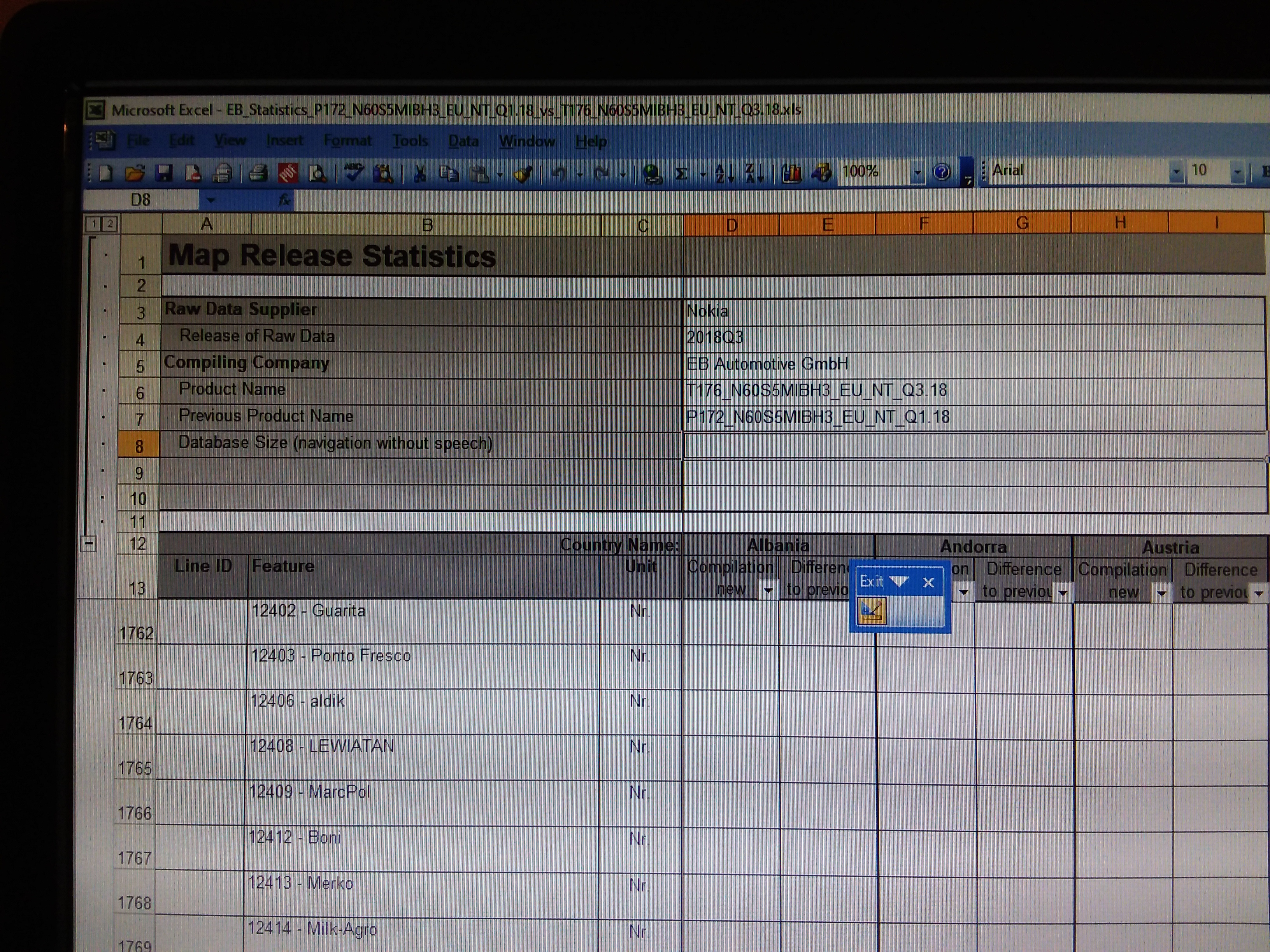
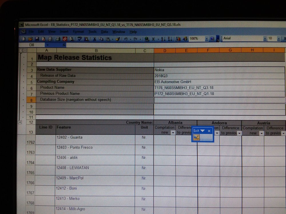
I believe a German digital mapping company does the work for VAG taking the Here Maps cartography plus associated files and generating the upload for the mib2 system. The company name crops up on the Excel spreadsheet that sometimes get released with the files. You look at properties and read it off :).... it was on a pivot they had produced between releases but it got shipped out with the files. I reckon it's them that need to address issues like that. You can dig about in the mib2 download files to find cartography relationships. The company is called EB Automotive GmbH. It's Seat that let this one slip out. The Skoda one of recent wasn't so interesting but excited the German Skoda Community Board.
-
You can format bigger than 32gb SD cards with ntfs or SD Formatter https://www.sdcard.org/downloads/formatter/ The old faithful. I'd just splash out and stick to 32gb SD cards, less than £7 from Amazon Prime. Just keep them for the job. Cheap enough. Needs to be class 10. VW and instructions are here https://webspecial.volkswagen.de/vwinfotainment/dam/jcr:c08aab64-ee73-4082-86a6-0fa82362282a/Discover Pro June_2019_EN.pdf I'd keep to the instructions and don't deviate. Covers Mac there as well. 7zip is here: http://www.7-zip.org/ Hole digging is when you deviate. They write the stuff for a reason since its tested and works. They don't say NTFS. Certainly if you format a 32gb card with NTFS it reported current map won't fit on it. On the standard system the units won't read NTFS and fail to work correctly. Also why I say don't use NTFS. All the issues appear when people go off piste. The Mac stuff again people have found alternative ways of doing it without CleanMydrive but any garbage in files related to Mac use or incorrect unzipping will stop it in its tracks. Best to do it by the letter which is in the VW guidance.
-
Yep SD is best. Class 10 or better. 32gb SD. I run with three. Keeping the last copy and the one before cycling them like back ups. Scrap of hand written paper on what's on each :). Don't write it on the sticker. 4k is good on the sector size but performance is better on an SD card. The missing space is the indexing that FAT32 creates on the image above related to sector size. Don't use NTFS whilst we are on the topic.